
Your cookie preferences - City of Bethlehem

Accepting cookies helps us improve this platform. Read our cookie policy.

City of Bethlehem Home
  • Home
  • Events
  • About
  • FAQ

Megan Lysowski

Member since November 15, 2023

I want better infrastructure for pedestrians and cyclists in Bethlehem - sidewalks, curb bump outs, separated bike lanes, galore!
All input submitted by this participant

There are 6 projects available.
Trending ideas have loaded.

Make Stefko Blvd Safe for Pedestrians and Cyclists

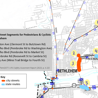
Megan Lysowski•3 years ago PennDOT released its vulnerable road user (VRU) survey in late 2023. VRUs include pedestrians, cyclists, and anyone who uses a mobility device. The report identifies high risk areas (HRAs) across Pennsylvania. HRAs are street segments that are unsafe for pedestrians, cyclists, and mobility device users. Using data from this report, I created a map highlighting these unsafe street segments in Bethlehem.Most street segments are state routes (highlighted in blue lines) which means PennDOT is primarily responsible for their maintenance and design. However, two portions of Stefko Blvd (highlighted in red lines) are city owned streets.How can we make Stefko Blvd safer for those who walk and roll?1 - Lower the speed limit on these portions of Stefko Blvd. Currently, these segments are set at 40 mph and 35 mph.2 - Add sidewalks or mixed-use trail on the East portion of Stefko Blvd between Washington Ave and E Broad St. The undeveloped properties are owned by the City of Bethlehem according to Northampton County tax records.3 - Narrow the driving lanes to 11 ft.Sources:PennDOT VRU Safety Report: A- VRU Safety Assessment Report - Single Pages_Proof 7.pdf see page 4-23 for Lehigh Valley identified street segments see page 4-46 - 4-47 for Lehigh Valley identified intersections see Chapter 6 for infrastructure and policy recommendations Northampton County: Northampton County - Address Search (ncpub.org)

Bike Infrastructure - Connecting Minsi Trail Bridge

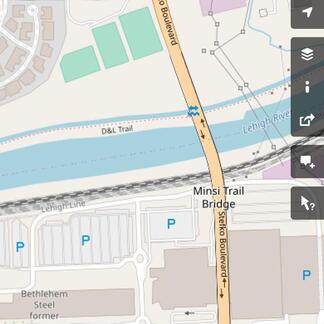
Megan Lysowski•3 years ago The Minsi Trail Bridge has access points to the D&L on the North side and the South Bethlehem Greenway on the South side. Both of these are popular destinations for cyclists and make riding and commuting a pleasant experience. Currently, the sidewalk measuring 5'6" at its widest cannot accommodate cyclists and pedestrians and the road is inhospitable to cyclists. I propose narrowing the driving lanes in order to widen the sidewalk and turn it into a barrier protected shared use path between 8-10ft wide. Users in the area who would benefit are Moravian Village of Bethlehem residents, a community for older folks; Laros Lofts residents, an apartment complex with 100 units; Lanta's blue line bus stops; Sands Casino patrons and employees; bicycle commuters; and other residents, both housed and unhoused, within walking/ biking distance of the bridge. Bike boxes and signage would be appropriate at the ends of the bridge to alert drivers to cyclists joining to roadway. The southern end of the bridge is currently designed well to encourage cyclists to flow to the greenway. The northern end could be designed to encourage cyclists to use E Market St and considerations should be made to improve the bike accessibility of Stefko Blvd and E Broad St for the future.Sidewalk measuring 5'6" at its widest. Wide vehicle travel lanes as seen from the north side. Experience of pedestrian and cyclist entering from north side.Updated 11/17 with pictures and more detail

Bike Boulevards to Everyday Destinations

Megan Lysowski•3 years ago I propose creating a network of bike boulevards (low vehicle traffic and speed streets) that connect to everyday destinations: grocery stores, K-12 schools, universities, and the transit center.Bethlehem has wonderfully connected streets making it easy to walk and bike to where your everyday needs are, but these routes and destinations are often car-dominated making the journey there difficult. The largest concern that prevents people from riding a bike is fear of car traffic.We can utilize existing roads where vehicle speeds are already lower like residential streets for bike boulevards. Proper signage, decreased speed limits and "BIKE BLVD" markings can indicate the route and alert cars to cyclist activity. The South Bethlehem Greenway has excellent examples of signage leading to different destinations and their distances. We can focus on upgrading intersections that are currently dangerous for pedestrians and cyclists.It is also important to recognize that the majority of the places we do our shopping are car-oriented and unfriendly to pedestrians and cyclists, for example Stefko Blvd Shopping Center and Lehigh Shopping Center. Even our small town shops are located on along our car main arterial routes: Linden St, Broad St, and E 3rd St. A network of safe bike boulevards would help make getting to everyday necessities safer and make riding a bike more accessible to all.We can look to cities of similar populations and resources as a role model for how they created a bike-friendly place:San Luis Obispo, CAWhite Plains, NYThanks!

E Broad St - Intersection Now for Bike Lane Later

Megan Lysowski•3 years ago E Broad St has received funding for the proposals listed in the Activate Broad Street Plan (linked below). These improvements include updated pedestrian crossing traffic signals, enhanced bus stops, high visibility crosswalks, pedestrian refuge islands, and curb bump-outs (also called curb extension, for ease of reading this proposal will use the term “curb bump-out”).A curb bump-out is an extension of the sidewalk at the intersection. It reduces the amount of road space a pedestrian has to cross and promotes visibility to drivers. Curb bump-outs are planned for Broad & Linden, Broad & Maple, and Broad & Elm. Here’s a sample of a curb bump-out intersection design from the Activate Broad St Plan:I propose we change the design to floating curb bump-outs at the three planned intersections. In addition to the benefits listed of a traditional curb bump-out, a floating curb bump-out enhances visibility and reduces the road crossing distance for cyclists. This design change would allow for the future of a parking protected bike lane. Using a diagram from NACTO's "Don't Give Up at the Intersection" (linked below), I created an illustration to show the difference:Here are some pictures of what a floating curb bump-out looks like in different scenarios (both from NACTO):This change will allow for a parking protected bike lane to be installed in the future. Some benefits of a parking protected bike lane on E Broad St: Reduce travel lane width from Stefko Blvd to Linden St for vehicles which prevents excess speed (see John Hopkins Study on Lane Narrowing for more info & Walk/ Roll LV Broad St recommendations) Safer access via walk and bike to LANTAs EBS blue stop on Stefko Blvd and the Minsi Trail Bridge Protected bike facilities encourage bicycle ridership and the presence of bicycles make vehicles slow down I think it is important to use this opportunity to plan for the future and make all of Broad St a place safe for walking and biking. Since the report was made in 2019, there has been the addition of an apartment building with a 116 units and LANTAs EBS blue line service has begun. Let's make these changes to reflect the recent past and plan for the future. Let's build these three floating curb bump-outs now using the resources provided, so we can build a bike lane later. Note: This plan would narrow the crossing distance between bump-outs to 24 ft. A pedestrian refuge island may not be practical.Thanks!Activate Broad St Plan: https://www.bethlehem-pa.gov/CityOfBethlehem/media/DCED-Media-Library/PlanningZoning/CommunityPlans/Broad-Street-Active-Transportation-Plan.pdf   see pages 21-24 for existing conditions (note conditions reflect 2019) of Center St to Stefko Blvd see pages 54 & 55 for improvements suggested from Linden St to Stefko Blvd see Appendix A for bikeway intersection sample designs (GIF created uses this image) see Appendix B for implementation metrics and project description list John Hopkins Study on Lane Narrowing: https://narrowlanes.americanhealth.jhu.eduNACTO "Don't Give Up at the Intersection": https://nacto.org/publication/dont-give-up-at-the-intersection/minor-street-crossings/NACTO One-Way Protected Cycle Track (another name for Parking Protected Bike Lane): https://nacto.org/publication/urban-bikeway-design-guide/cycle-tracks/one-way-protected-cycle-tracks/#:~:text=Description,the%20motor%20vehicle%20travel%20lane.Walk Roll LV Plan - https://lvpc.org/pdf/2020/WalkRoll/WalkRoll%20Reduced.pdfsee pages 114-115 for Broad Street Plan

Sidewalk Repair/ Replacement

Megan Lysowski•3 years ago Sidewalk repairs and replacement are the responsibility of the property owner here in Bethlehem. Currently, the city does not enforce this ordinance (Article 909 linked below). Our current mayor and previous mayor did not want to put the cost burden of sidewalk repairs and replacement on the homeowner. Understandably so, the cost of concrete sidewalk repairs can cost anywhere between $3 and $20 per sq foot of new sidewalk (cost estimates come from Forbes article linked below).Many homes in Bethlehem are on 20 ft wide lots (think twin row homes in the Northside). Assuming the sidewalk is ADA compliant at a minimum of 5 ft wide, a property owner is responsible for 100 sq ft of sidewalk. If the property owner needs to replace all 100 sq ft of sidewalk then the cost estimates are between $300 and $2000.A large way to reduce costs and get your sidewalk repairs closer to the $300 range is to do it yourself. If the resources are made available, I think property owners can DIY!I propose we create a non-profit organization to provide free or low-cost sidewalk repairs/ replacement resources for property owners to make the repairs/ replacements themselves.This non-profit would cover city fees, project materials, tools, and public liability insurance to allow property owners to DIY sidewalk repairs/ replacement. A team could include a contractor to ensure city specifications are met, a lawyer to ensure the non-profit's public liability insurance covers property owners, and an administrator to complete permits and coordinate with DPW for timely inspections.Note: An important part of this idea hinges on the legality of a non-profit providing public liability insurance coverage for individuals or volunteers. I do not know how the organization would need to be setup for this to work. If you work in insurance or law, please chime in!Update (12/12/23): After learning more about this issue, public liability insurance cannot be issued to a property owner via a non-profit. The administrative hurdles are not the barrier it is the cost foremost. I’m not sure what the answer is here to fix our sidewalks, but something needs to change. Suggestions always appreciated.Thanks!References:ADA Compliance Sidewalks and PennDOT:https://gis.penndot.gov/BPR_PDF_FILES/Documents/LTAP/TechSheets/TS_208_Sidewalks_and_ADA.pdfBethlehem Engineering Permit Application:www.bethlehem-pa.gov/CityOfBethlehem/media/PWMedia/Engineering/EngineeringPermitApplication2018.pdfBethlehem Ordinance Article 909 - Sidewalks, Curbs, Gutters and Driveways:https://www.bethlehem-pa.gov/CityOfBethlehem/media/Ordinance-PDFs/ARTICLE0909.pdf?ext=.pdf Forbes Concrete Sidewalk Repair Costshttps://www.forbes.com/home-improvement/driveway/concrete-sidewalk-repair-cost/

"Daylight Intersections" Pedestrian Safety Using Existing Local Law

Megan Lysowski•3 years ago Bethlehem's parking ordinance prohibits standing or parking a vehicle within 20 ft of a crosswalk at an intersection.In other words, it is illegal to park or idle your car right up to the crosswalk. There should be a 20 ft gap, which about one parking spot length.Blocking off this space in front of the crosswalk is called "daylighting." It makes pedestrians, cyclists, and other vehicles more visible to one another. Strong Towns has a recent article about it, if you want to learn more. The intersection of E North St and Maple St are excellent examples of daylighting. Another great example is the cover photo of this committee.On a walk around the Northside I found varying degrees of infrastructure indicating this law: Some intersections have a "no parking" sign, "no no no" painted on the ground, a curb bump out, or vertical barriers.More often than not, I see no infrastructure enforcing this law, and personally, I have not heard of any tickets being distributed for this violation. I propose we aim to daylight all our intersections. We can begin by prioritizing our high crash intersections (For example, Union Blvd & Center St, E Union Blvd & Maple St).If we can see each other, then we can stop for each other.Thanks!
  • Terms and conditions
  • Privacy policy
  • Cookie policy
  • Accessibility statement
  • Site Map
Powered byGo Vocal formerly CitizenLab
English
  • Português
  • Español